
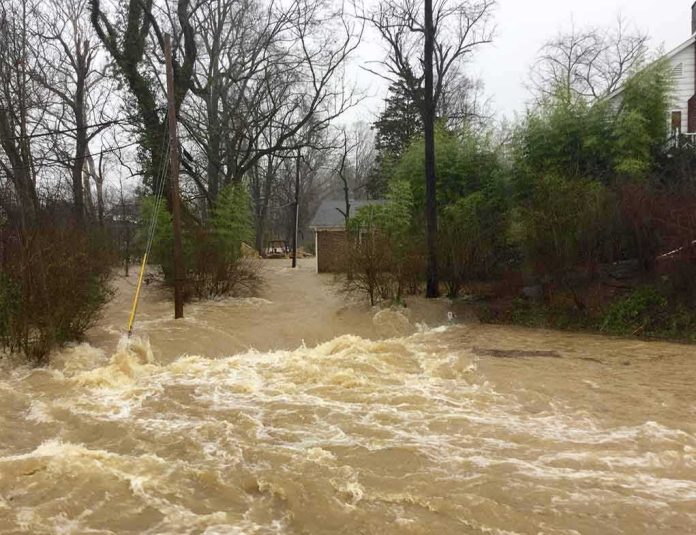
Nearly a foot of rain fell on parts of New York’s Hudson Valley in late July, triggering flash floods that collapsed a home, closed dozens of roads, and pushed Governor Kathy Hochul to request federal disaster aid.
Story Snapshot
- Flash floods struck the Hudson Valley repeatedly through July 2026, with the worst damage on July 29-30.
- Rainfall topped 6 inches in some spots, with local totals near 10 inches in the Hudson River Valley.
- Governor Hochul asked for federal help to clean up after the storm hit the region.
- The National Weather Service logged flash floods on July 14, July 18, July 28-29, and July 31.
- Rescues, evacuations, and a partial road collapse were reported across affected counties.
A Month of Repeated Flooding
The Hudson Valley faced flash flood warnings and watches almost every week in July 2026. The National Weather Service’s storm archive lists separate flash flood events on July 14, July 18, and July 31, each hitting overlapping parts of the lower Hudson Valley, New York City, and northeast New Jersey. That pattern shows a region that stayed on edge for weeks, not just during one single storm.
The Worst Night Comes Late July
The most damaging flooding hit on July 29 and 30, when slow-moving storms dumped heavy rain across eastern New York for hours. Flash flood warnings covered the Hudson Valley as rainfall totals topped 6 inches in some areas, and more than 11 million people sat under flood alerts across the region. The rain fell on top of ground already soaked from earlier storms that month.
Local outlet lohud reported flash flooding across the Lower Hudson Valley that Wednesday morning, with video showing water covering roads in Philipstown. A stretch of highway in West Nyack closed in both directions because floodwater made it impassable. Similar scenes played out in Westchester, Rockland, and Putnam counties as storm drains and creeks overflowed faster than crews could respond.
Historic Totals Draw Irene Comparisons
Rainfall in parts of the Capital Region and Hudson Valley reached levels not seen since Tropical Storm Irene struck nearly 15 years earlier. The storm flooded homes, stranded drivers, and washed out roads, prompting water rescues, emergency declarations, and evacuations as creeks spilled over their banks and storm sewers backed up across neighborhoods. Local officials in the Capital Region opened emergency shelters as the water kept rising overnight.
In Highland Falls, near West Point in Orange County, the flooding proved severe enough that Governor Hochul requested federal aid to help pay for cleanup after the weekend storm. Many roads in Orange County and the Bronx stayed closed for days afterward, including Route 9W, Route 202, and sections of the Palisades Parkway. The closures cut off normal commutes and forced residents to find long detours around washed-out crossings.
Weeks of Warnings Before the Worst Hit
The late-July disaster did not come without warning. Forecasters issued a flood watch for the mid-Hudson Valley on July 28, projecting up to 5 inches of rain across Dutchess, Ulster, and Orange counties over roughly 24 hours. New York City itself sat under a flood watch that same Tuesday, with forecasters warning of over 5 inches of rain and the risk of life-threatening flash floods reaching into Long Island, Connecticut, and New Jersey.
Nearly 300 years of history are gone in an instant.
Flash flooding tears through New York's Hudson Valley, sending a historic gristmill built in the 1640s crashing into the floodwaters.
The building served generations as a working gristmill before pic.twitter.com/T7NOhKhyJ2— Dr. Chris Martenson (@biancarichard_s) July 31, 2026
Earlier storms in July had already tested the region’s flood defenses. A July 21 storm forced most Hudson Valley roads to reopen only after flooding and downed trees caused major traffic problems, including a partial road collapse near Legion Drive and Virginia Road. That earlier round of damage left crews and residents with little recovery time before the more severe late-July flooding arrived.
What Comes Next for Storm-Weary Residents
Repeated flash flooding this July raises real questions about how prepared aging roads, drains, and bridges are for storms that keep arriving back-to-back. Federal aid requests now move through the usual review process, while residents in Orange, Westchester, and the Capital Region face months of repair work. No single agency has offered a timeline for when all affected roads will fully reopen.
Sources:
youtube.com, lohud.com, wamc.org, instagram.com, facebook.com, nypost.com, newjersey.news12.com